Is it a bird? Cows may think so. Is it a plane? No, but it requires precision to fly.

So what is that small, lightweight, quiet airborne machine causing such a buzz in the agricultural sector?
That is an unmanned aerial vehicle, or UAV – what many commonly refer to as a drone.
You may expect to find UAVs in war zones or on a Hollywood movie set. But the aircraft’s versatility, agility and precise imagery have led many to explore its use in new territories: cropfields and livestock pens.
Agriculture continues to embrace developing technologies that help people farm more efficiently, and UAVs are no exception.
At Lake Region State College in Devil’s Lake, North Dakota, enrollment in the two-year precision agriculture program can barely keep up with the high student demand, says Paul Gunderson, director of the college’s Dakota Precision Agricultural Center. The program now offers a ground school where students can learn to operate UAVs.
“We believe that engaging in the kind of training that we are doing, ground school-wise, is absolutely imperative,” Gunderson says.
What is the potential?
UAV manufacturers market their products to the agricultural sector largely for crop scouting. Those who scout on foot often visit less than 2 percent of a field, says Thomas Harris, vice president of products and data services at Agribotix, a Colorado-based UAV company.
A UAV’s ability to fly low and collect high-resolution images makes it valuable in stand counting, Harris says. With aerial imagery, growers can also identify disease, pests and nutrient deficiency, says Lia Reich, senior communications director for the UAV company PrecisionHawk.
“The responsive nature of this technology gives farmers a cost-effective way to collect consistent and time-sensitive data and turn that into an action that will impact their resource management or yield,” Reich says.
With near-infrared cameras, growers can collect even more information about crop health. Densely planted, healthy vegetation reflects more infrared light than less healthy vegetation, Harris says.
In the livestock industry, aerial images of pastures could indicate changes in vegetation, drainage, erosion or snowdrift, says Camille Goudeseune, computer systems analyst at the University of Illinois – Urbana-Champaign’s Beckman Institute.
Livestock producers could observe not only stationary crops but also moving animals. This may be especially helpful in large pastures of beef cattle.
“The day of the pen rider is numbered,” Gunderson says. “The moment these technologies are perfected, we won’t need pen riders anymore, whether on horseback or ATVs, because we can place staff in front of a computer screen in our office, and they are not only much safer, but they are also much more productive because they are flying right over the top.”
If the vehicles could autonomously take off and dock at charging stations, producers could preprogram flight paths to monitor herds while they sleep, Gunderson says. In North Dakota, this could mean avoiding a frigid winter walk in wind chills that dip to 40ºF below zero.
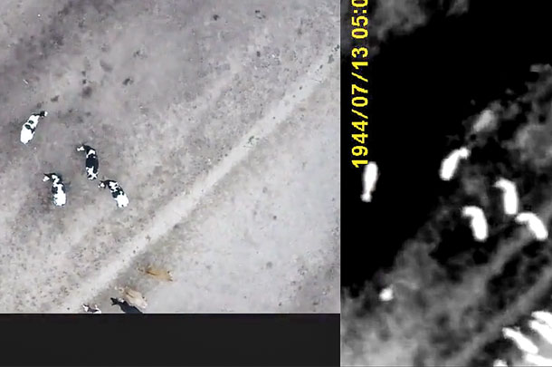
UAV platforms can be fitted with thermal sensors capable of registering livestock body temperatures. As these continue to develop, they may help in monitoring estrus on dairy operations, Goudeseune says.
 The thermal sensors can also aid early disease detection. PrecisionHawk’s radiometric thermal sensor can detect temperature differences as minute as a half-degree, Reich says.
“Cows with a very high fever can have temperatures run as high as 107 to 110 [degrees Fahrenheit], which would easily be distinguishable with this sensor,” Reich says.
However, looking for abnormally high body temperatures can be complicated by an animal’s daily temperature cycle as well as temperature-elevating activities like exercise and feeding, Gunderson says. If using infrared sensors, heat emanating from the sun and the ground may make images less reliable than a direct rectal temperature, he says.
But infrared imaging can still be valuable in disease prevention. Goudeseune and faculty at the UIUC College of Veterinary Medicine are using infrared images from UAVs to monitor cattle behavior that may be early indicators of disease. These include time spent at the feedbunk or water trough, the number of social interactions and the amount of time spent moving and lying down, says clinical professor Dr. Brian Aldridge.
UAVs could also help ensure biosecurity protocols are effective, monitoring feedbunks for unwelcome wildlife that may defecate on feed, Gunderson says.
Aerial observations of behavior and movement may indicate how animals are adjusting to new environments, Aldridge says. They can also monitor the strength of cow-calf bonds and response to predator pressure, he adds.
New agricultural applications continue to be uncovered, sometimes unintentionally. For example, while Goudeseune and his team were taking infrared images of cattle, they also caught glimpses of silage bags on the university’s dairy farm.
Dairy farm manager Henry Hoene was excited by the results. Black spots on prepared bags represented good feed that had fermented and cooled off, while white hot spots indicated mold.
“Although others have used handheld FLIR cameras for this, a copter flying a preprogrammed path low over a farm’s clamps could deliver a stitched image via its ground station to a farmer’s smartphone within a few minutes of completing a flight, with hardly any manual intervention,” Goudeseune says.
While this imaging may not penetrate large silage piles well, it can save time by avoiding bad spots in bags of silage during feed preparation, Hoene says.
What do cattle think of all this?
According to Gunderson, the animals view UAVs as they would a large bird of prey. When the aircraft is flown at low levels in an animal’s flight zone, they tend to move away slowly before turning back for another curious look. This could make the UAVs a valuable tool in moving cattle and other herd animals.
What are the options?
With a variety of different platforms and sensors available, growers and producers can collect a magnitude of information with UAVs.
But first they must select the aircraft that is right for them.
“There are a number of options out there, but when it comes down to it, the reason someone is using this technology is to gain a better perspective, better information,” Reich says. “Collecting good-quality data on the front end is imperative to receiving actionable information that will inform business decisions when all is said and done.”
One individual working to keep growers informed and up to date with this burgeoning technology is self-proclaimed tech geek Chad Colby.
“The technology has evolved so much that it’s really going to revolutionize agriculture,” Colby says.
Through his website, www.agtechtalk.net, as well as Twitter and Facebook, Colby showcases the latest products from industry leaders and shares insight to help farmers make informed purchases.
One of the common misconceptions is that more expensive aircraft must be better, Colby says. As with other technologies, UAVs are advancing so quickly that the price of quality systems continues to decrease.
Two main platforms exist for the UAVs used in agriculture: fixed-wing and quadcopters.
Quadcopters have superior maneuverability and stability, whereas fixed-wing platforms are faster and can cover more distance in a single charge, says Gunderson.
However, companies like Agribotix have worked to improve multi-rotor platforms so that they can cover 160 acres in a battery’s lifespan, like their fixed-wing counterpart, Harris says.
At Lake Region State College’s UAV ground school, training to operate fixed-wing platforms takes at least twice as long due to more complicated take-offs, landings and banked turns, Gunderson says. Even with Agribotix’s fully-autonomous fixed-wing craft – called the Hornet – the operator will often want to manually assist with landing, Harris says.
What are the challenges?
Producers and farmers need information about their livestock and crops, no matter the weather. This means UAVs must have increased ruggedness, Gunderson says. Models in which the current flows outside the central frame will short out when exposed to precipitation.
Students must also learn to compensate for wind and turbulence from tall farm structures such as silos to avoid crashes and flyaways, Gunderson says.
Although with practice quadcopters can be flown an inch or two from barn rafters, using the aircraft indoors is still a challenge because metal roofs interfere with GPS signals, Gunderson says. The researcher has successfully used radio frequencies to overcome this problem.
 Perhaps more challenging than flying is processing data.
“Processing imagery from drones is time-consuming and requires expertise in specialized geospatial software,” Harris says. “Operators flying frequently and attempting to run all their own data processing talk of having to work double shifts, flying during the day and processing data at night.”
Gunderson says that it has taken him 16 hours to stitch images from some quarter-sections. Stitching also requires flight paths to overlap by some 60 percent, he says.
“I have never talked to a producer who told me they didn’t have enough to do,” Gunderson says. “They are not looking for more work. For the most part, what they are trying to do is farm more expertly and wisely, and if that takes a huge pile of additional work, that is a significant impediment to adoption of the technology.”
Many companies are working to simplify and speed up this process. Agribotix offers an upload interface that provides results within four business days, Harris says. PrecisionHawk’s analytical tools operate in the Algorithm Marketplace, open-source software that allows researchers, universities and GIS experts to expand it, Reich says.
Some in the industry are working to process data while the craft is still in the air and autonomously control the ship’s flight path and camera settings, Colby says.
What are the regulations?
It is crucial that agriculturalists understand the rules and risks associated with UAVs before they buy or fly, Colby says.
“You are in an airspace that has been controlled extremely safely for all my life and generations before us,” he says. “You’re entering that with unmanned stuff, and that complicates things immensely.”
Crop dusters have shared their concerns regarding UAVs with Gunderson, namely that the crafts do not regularly transmit electronic signals or have beacons. They also worry that operators do not have proper aeronautical training.
The Department of Transportation’s Federal Aviation Administration, or FAA, currently has separate UAV regulations for recreational and commercial use. For farmers, the distinction can be a bit tricky.
Under current regulations, recreational users do not need special permission to fly UAVs under 55 pounds from the FAA so long as they follow the established safety guidelines.
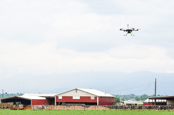
As Cornell University Cooperative Extension explains, as soon as a producer or grower makes a management decision based on UAV imagery, they are no longer a hobbyist but a commercial user. This type of commercial operation requires a Section 333 exemption from the FAA and additional certification.
More information about regulations and applications for commercial use can be found at knowbeforeyoufly.org
In February, the FAA proposed new rules regarding small UAVs used for non-recreational purposes that would replace this exemption policy. The FAA is currently reviewing public comment.
These new regulations would allow UAVs weighing up to 55 pounds to operate within line-of-sight, below 500 feet and at speeds less than 100 mph during daylight hours. Operators would need to be age 17 and older and pass an initial aeronautical knowledge exam with follow-up tests every 24 months.
“The proposed rule will create a lot of value by unlocking that opportunity for more people to begin flying and collecting the data that they need to meet their business use cases,” Reich says. “We anticipate a significant increase in sales in the U.S.”
What are the limits?
Whether locating a cow in a cornfield or spoiled feed in a silage bag, UAV platforms, sensors and software find a wide variety of uses for growers and producers.
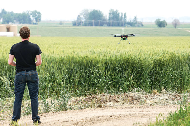
As with any technology, the only limit for UAVs in precision agriculture is human imagination. PD
Holly Drankhan is a student at Michigan State University College of Veterinary Medicine.
PHOTO 1: As soon as a producer or grower makes a management decision based on UAV imagery, they are no longer a hobbyist but a commercial user. Photo courtesy Thomas Harris.
PHOTO 2: UAV platforms can be fitted with thermal sensors capable of registering livestock body temperatures. Photo courtesy Dr. Steve Joslyn.
PHOTO 3: The only limit for UAVs, or drones, in precision agriculture is human imagination. Photo courtesy Thomas Harris.

