AgVu Building C #3105 More than 10 years ago, Advanced Reconnaissance Corp. (ARC) used infrared imaging technology for the U.S. Department of Defense for geological studies.
Then 9-11 happened, and ARC technology was used overseas to help the troops detect improvised explosive devices. At World Ag Expo 2013, ARC launched the same technology for an agricultural application and called the new venture AgVu.
AgVu’s concept is to fly over cropfields using commercial airplanes while taking infrared images of customers’ crops. The data is collected, processed and reviewed with the customer within 72 hours of data collection.
The value of infrared imaging is that it identifies stresses in crops before they are visible to the naked eye. ARC’s AgVu program manager Sean Westfield says, “Any time there’s a variation from the healthy crop, we’ll see it – from low irrigation to weeds to pest infestation or disease – anything that puts a stress on the crop.”
The infrared imaging technology is not crop-specific, and applications of the technology can vary from use with strawberries to pistachio and almond trees.
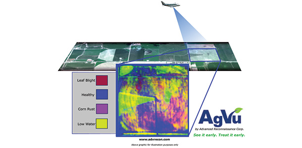
The technology doesn’t care what it’s looking at; it’s only interested in finding deviations from what was originally programed in as being a “healthy crop,” which is determined at the beginning of the season with the farmer.
Westfield says what sets their company apart is that the industry standard uses an NDVI (normalized differential vegetation index), a two-band comparison that tells you if there are plants or not, while AgVu uses a 151-band comparison done simultaneously that tells you not only the index but shows anything that’s different from a healthy crop.
Westfield says, “We’re not farmers, and we don’t pretend to be,” and communication with the farmer in establishing the baseline and determining plant pressures is vital to success of the service.
Once an issue or plant pressure is identified, actual ground analysis must be conducted to clearly determine the problem. “Then we put that pattern into our software so when the pattern comes up again, the system learns what something is,” Westfield explains.
More information about this product can be obtained by sending an email .
GeoBlu Services
Building C #3902
GeoBlu Services is an unmanned aerial vehicle (UAV) development and services company based in Phoenix, Arizona. Their services capture imagery data for real-time on-site and off-site viewing.
GeoBlu Services is a fusion of technologies centered on UAVs and data collection providing cost-effective UAV solutions used in image analysis and remote sensing.
UAVs can be used to track wildlife and take livestock “head counts.” They can provide new insight into animal behavior as well as protection from poachers. With the ability to operate at night, and with thermal camera sensors, UAVs provide unprecedented protection, according to the company website.
UAVs can fill a gap between manned aerial inspections and traditional fieldwork by monitoring hard-to-reach areas or taking readings in contaminated areas where human health would be at risk. The ability to quickly deploy and capture an area of interest in concert with position measurements provides an advantage to producers.
Near-infrared sensors provide details of plant health to determine environmental health. UAV aerial data can produce prescription maps to aid farmers in determining crop stress levels, drought indicators, temperature effects and water, and fertilizer variation and more.
Editor’s note: At the time of this writing, we had not received communication from GeoBlu to verify the launch of their services, and all information describing their services was gained from the geobluservices.com company website.
Mark Blanks, UAS Program Manager at the Kansas State University Applied Aviation Research Center, states the Federal Aviation Administration (FAA) does not yet allow commercial use of UAVs.
However, the FAA Modernization and Reform Act of 2012 mandates that the FAA must integrate unmanned aircraft into civil airspace by September 2015, which means legal commercial operations may not be far away.
In November 2013, the FAA released the FAA UAS Roadmap 2013, which lists a projected timeframe for FAA approval for selected test sites as third quarter 2015, and approval for use of GBSAA (ground-based sense and avoid) for educational and other public applications granted by 2016-2018, subject to approval processes. PD


