Issue 16 of Progressive Dairyman (Oct. 10, 2017) highlighted the Rural Firefighters Delivering Agricultural Safety and Health (RFDASH) project from the National Farm Medicine Center.

This project encourages rural emergency responders to help prevent farm injuries and fatalities by engaging in a four-part curriculum.
This issue highlights one of the free tools the project utilizes: Farm Mapping to Assist, Protect and Prepare Emergency Responders (Farm MAPPER). This online tool not only enables firefighters and other first responders to be best prepared to respond to a farm emergency, but can actually prevent such emergencies from occurring in the first place.
We have fewer firefighters who work in or have grown up with an agricultural-based background. Therefore, familiarity with farm equipment and the farm environment is less common.
Basic training courses often do not include the time to cover agricultural accident responses. Yet the mandates to respond safely at multiple levels exist for every agency. Farm MAPPER was designed with some of these issues in mind.
Latest data from the USDA shows the average U.S. farm is 442 acres (2016 data). If you are a farmer, imagine an incident occurs on your farm and you have to provide a 911 dispatcher and first responders with the specific location of an emergency incident.
If you are a firefighter or emergency medical technician, imagine responding to an emergency and navigating across more than 400 unmarked acres.
If the task seems daunting, it is because responding to emergencies on farms is often difficult. Farms have machinery, chemicals, flammable agents, multi-story structures, unique electrical systems, livestock, human occupants, lagoons, weight-limiting bridges, remote worksites and waterways, and can be spread over large, complex areas despite having a standard home address.
While fires are only one kind of emergency that can occur on farms, they are particularly costly to the farm owner and to society. According to the U.S. Fire Administration, 20,000 agricultural-related fires cause approximately $102 million in direct property losses and result in 25 fatalities per year. Agricultural fires are about 9 percent more expensive than other industrial fires.
The number and makeup of volunteer fire/rescue departments have changed considerably over the years. All volunteer departments encompass 67 percent of fire and rescue departments nationwide, according to U.S. Fire Administration statistics from 2015.
Unlike other businesses, farms are often not required to engage in pre-planning with their area fire department. Therefore, fire departments must work closely with farmers to be granted access and learn about their individual operations.
Farm MAPPER is a free, easy-to-use mobile tool to help firefighters conduct pre-planning on farms. The tool can be accessed online (www.nfmcfarmmapper.com). Users can type in an address and a birds-eye view of the area will appear. The tool provides an array of potential farm features that can be geo-located onto the map (see Figure 1).
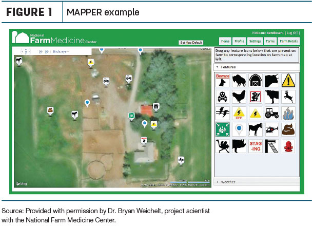
(There are ongoing additional efforts to display mapped items in a heads-up display using augmented reality software.) Possible staging and airlift areas, water sources, electrical shutoffs and chemical/flammable storage are high-priority topics. These features not only serve as landmarks to assist in directing first responders to an emergency but also are common hazards that can endanger their lives.
Additionally, maps are secure and password-protected on Marshfield Clinic servers, so farmers and firefighters can both be assured the information about a farm contained in a map will be kept safe. The server is accessible nationwide.
Another important feature of Farm MAPPER is the ability of the map to be accessed en route to emergencies. If a mapped farm reports an emergency, first responders can bring up the map on any mobile-enabled device such as a phone or smart tablet.
While on the way to the farm, they can locate the specific site of the emergency and identify potential hazards to avoid that can make the emergency more severe or endanger the lives of first responders. RFDASH trainers will be trained to map farms in Farm MAPPER using a real farm as a test site.
Many hazards present on the farm (manure gases, propane, etc.) can threaten the lives of first responders if a pre-plan is not established. Fires and serious emergencies can also put a farm’s future at risk. Farm MAPPER provides a way to prevent the loss of the farm, family members, workers and first responders by providing an easy-to-use tool to aid in pre-planning farms.
Farm MAPPER is one important component of the RFDASH project, which broadly aims to make farms safer for everyone by equipping first responders with agricultural safety and health tools.
Connect with your area fire department to see about pre-planning your farm with the Farm MAPPER tool. If you are involved in your fire department, please inquire about being trained in the RFDASH curriculum by emailing Casper Bendixsen. ![]()
Casper “Cap” Bendixsen, Ph.D., is a social-cultural anthropologist and associate research scientist at the National Farm Medicine Center. His team includes research specialist Kate Barnes, MS, MPH, who co-authored this installment.
This project is supported by a grant from the Centers for Disease Control and Prevention-National Institute for Occupational Safety and Health (CDC-NIOSH), in collaboration with the Upper Midwest Agricultural Safety and Health Center.

-
Casper ‘Cap’ Bendixsen
- Associate Research Scientist/Cultural Anthropologist
- National Farm Medicine Center
- Email Casper ‘Cap’ Bendixsen


